Monja Copper-Gold Project
The Monja Copper-Gold Project is located in Loja Province, Ecuador, covering 9,088 hectares across two licenses. A review of historical data and field reconnaissance has been completed.
The project lies on the northeast margin of the Lancones Basin, which hosts recognized volcanogenic massive sulfides and porphyry deposits including the giant volcanic-hosted Tambo Grande massive sulphide deposit¹ and the Rio Blanco porphyry² in Peru. The project is also in close proximity to the Sunstone Metals’ Bramaderos³ porphyry project in Ecuador.
Initial mapping and sampling has identified a copper-gold porphyry system containing a two kilometer by one kilometer central core (press release from April 8, 2026) within a Paleocene-Miocene metallogenic belt known to host multiple significant copper deposits in southern Ecuador. Mineralization observed to date includes hydrothermal breccias with pyrite-chalcopyrite matrix, quartz-sulphide stockwork veining, and locally bornite, together with well-mineralized tourmaline breccias, all considered strong indicators of porphyry fertility.
Initially, a total of nine rock chip samples were collected from mineralized outcrops. Three returned encouraging results:
- Sample 51584: 4.77% Cu, 1.12 g/t Au, 19.5 g/t Ag, 74 ppm Mo
- Sample 51583 and 51587 also returned elevated copper and gold values
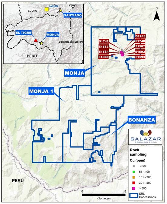
Extended Rock and Soil Sampling, Detailed Geological Mapping (press release June 30, 2026)
Rock Sampling Results
Of 99 rock samples, 64 samples (64%) returned copper values greater than 300 ppm and 20 samples (20%) exceeded 1,000 ppm Cu. Selected high-grade results are presented in Table 1 below.
|
Sample |
Au (ppm) |
Ag (ppm) |
Cu (ppm) |
Mo (ppm) |
Notes |
|
200101 |
0.989 |
10.3 |
17,070 |
162 |
Highest Cu-Au |
|
200079 |
0.613 |
2.7 |
10,940 |
10 |
|
|
51744 |
0.608 |
10.4 |
12,910 |
9 |
|
|
51748 |
0.644 |
1.5 |
6,250 |
4 |
|
|
700154 (channel) |
0.252 |
1.2 |
5,363 |
4 |
Note: Rock chip samples are selective in nature and may not be representative of the overall mineralization.
Soil Sampling Results:
A total of 23 soil B-horizon samples were collected along three north-south oriented lines on a 100 m × 100 m grid. Sixteen samples (70%) returned copper values exceeding 100 ppm, suggesting lateral continuity of copper mineralization over an area of approximately 180,000 m². Individual soil values ranged up to 2,242 ppm Cu.
Detailed Geological Mapping -Creek 1
Detailed mapping along a southwest-to-northeast trending creek (“Creek 1”), measuring approximately 150 m, has provided continuous exposure of the mineralized system.
Mapping identified well-developed stockwork veining, with densities averaging approximately 10 veins per meter. The dominant structural orientation is northwest-southeast.
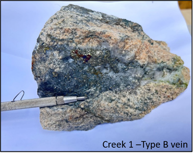
Most observed veins are quartz-rich and contain pyrite, chalcopyrite, and bornite, Type B. Some veins exhibit sericite alteration halos, proposing an overprinting of phyllic alteration with Type D veins². Map 1 and Image1.
Image 1. Creek 1 – Type B vein with quartz, chalcopyrite, bornite and pyrite.
Map 1. Creek 1 detailed map.
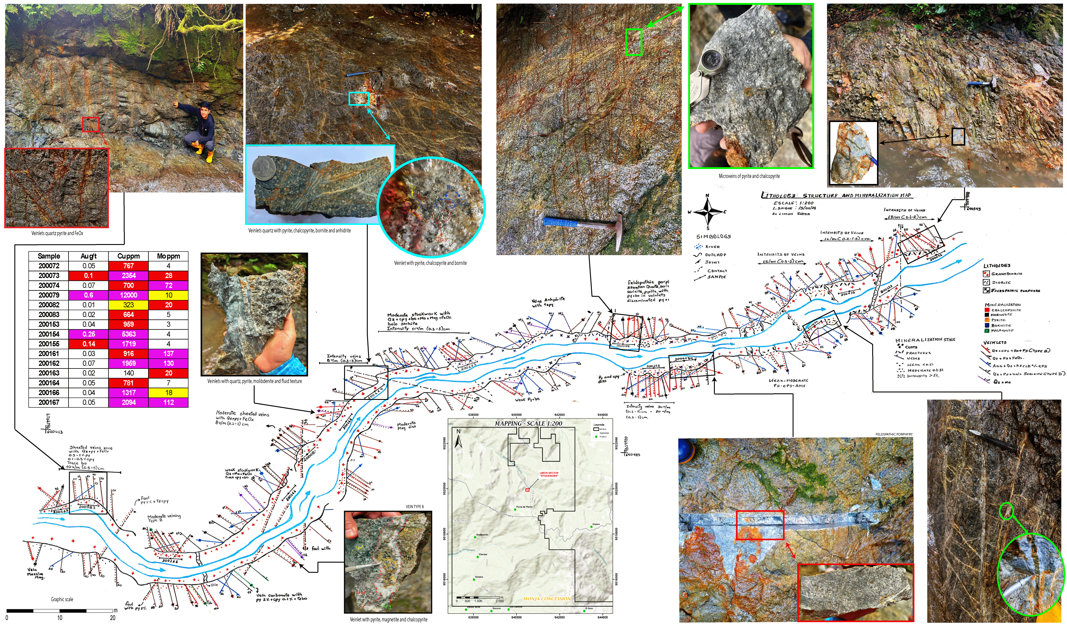
Collectively, these results confirm porphyry-style mineralization over an area of approximately 1.5 km × 0.5 km within the broader 2 km × 1 km porphyry core identified in April 2026. The alteration distribution — propylitic to phyllic and argillic assemblages with localized K-feldspar and magnetite — is consistent with a vertically and laterally zoned porphyry system.
3. www.sunstonemetals.com.au/site/projects/bramaderos-gold-copper-project/overview