Salazar Resources has the option to acquire up to 100% of the Los Santos 2.1 gold project via a staged option payment schedule. See here for a news release dated December 10, 2020.
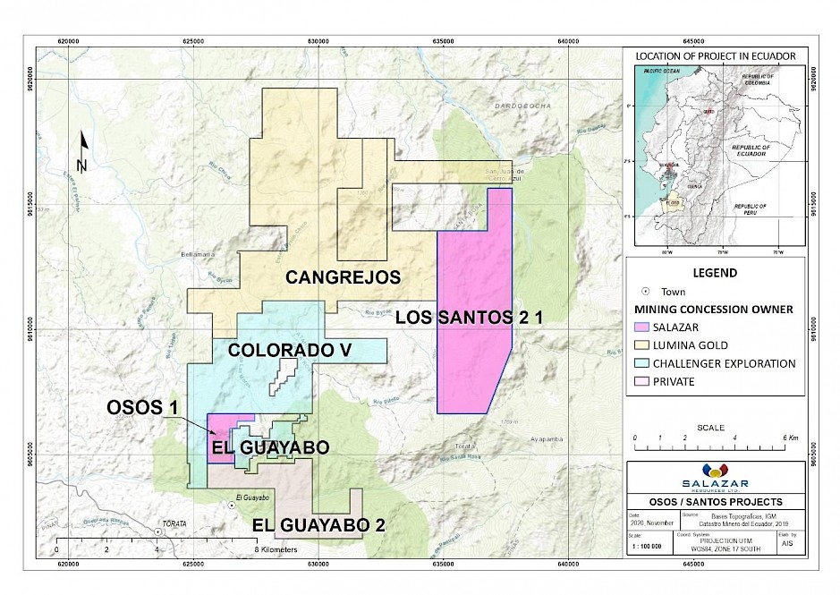
LOS SANTOS 2.1
Los Santos 2.1 lies in southwest Ecuador between the towns of Pasaje and Paccha in a district with a well-established tradition of gold panning and artisanal gold mining. The northwest portion of the concession area is less than 2 km from the centre of the Cangrejos main mineral resource, held by Lumina Gold. The project area is accessed via gravel roads, with elevations between 360 m and 1766 m, and there is a prominent north-south-trending ridge extending through the centre of the concession.
The Los Santos 2.1 concession was originally held by a private company Ecuanor in the early 1990s before being transferred to Minera Mesaloma in 2005. The area has been subject to surface exploration (geological mapping, soils and stream sediment geochemistry sampling and analyses, and regional magnetic and VLF electromagnetic surveys), principally on the east side of the property. Historic exploration data generated by Newmont Corporation and Compania Minera Silex Ecuador S.A. have been integrated into the database.
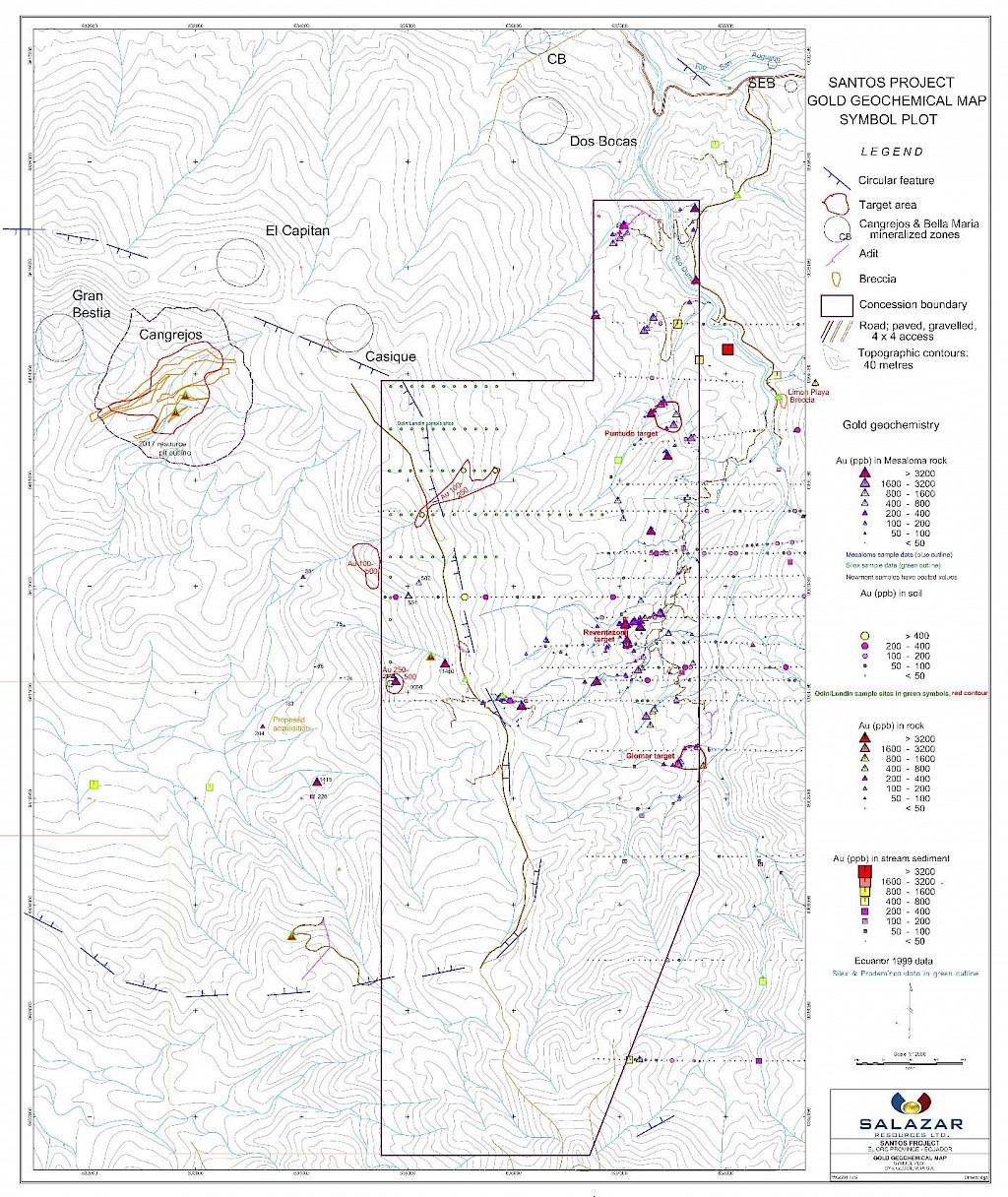
Figure 1. Location of Los Santos 2.1 in the Cangrejos district
Geology
Anomalous gold and copper-gold results are widespread in the area and occur within the intrusions and adjacent volcanic and metamorphic rocks. Many of the target areas appear to be associated with nested circular features interpreted to be a collapse structure or caldera margin. Salazar Resources’ geologists confirm that the geology at Los Santos 2.1 is similar to that of Cangrejos and Los Osos being gold-copper, silica-saturated, alkalic porphyry-style mineralization with abundant evident of mineralised hydrothermal breccias.
During 2021 Salazar Resources advanced several mineralized target zones within the 2,200 Ha concession, with systematic mapping and sampling . The main host rocks identified to date at Los Santos are weakly sheared, medium-to-coarse-grained granodiorites. The general orientation of the rock fabric and associated structures in the concession is broadly north-south, varying approximately 20o east or west. Where shearing is more pronounced, the structures range in width from a few centimetres to up to twenty meters in width. A number of tunnels have been dug by artisanal miners or prior owners of the licence area. In places tourmaline-rich hydrothermal breccia intrusions have been identified.
Historic Work
A program of geochemical soil and rock sampling was conducted on the former Los Santos concession during the period 1996 to 1999 and which covered the eastern part of the current Los Santos 2.1 concession. Flagged and/or cut lines were established at intervals of 100 to 1000 metres. Soil samples were collected with an auger at 50 metre intervals. Rock samples were collected where any mineralization or alteration of interest was noted.
Results of historic sampling over the concession and adjacent area are presented as gold, copper and arsenic symbol plots in Figures 2-4. These plots include all available data including Minera Mesaloma`s sampling and data which the Company has assumed to be reliable and which has been acquired from other sources. A few lines of soil sampling conducted by Odin Mining & Exploration Ltd. (now Lumina Gold Corp.) cross onto the Los Santos 2.1 concession, as shown on the gold and copper plots. A qualified person has not verified the historic data for Salazar Resources, and Salazar Resources intends to test the areas with fresh sampling and work. The figures are included for illustrative purposes only and to demonstrate the partial extent of historic work on the area. The
The gold plot (Fig. 2) shows widespread scattered anomalies (+500 ppb in soil, rock and stream sediment) throughout the Giomar, Reventazon and Puntudo areas as well as in two additional areas on the western side of the property. Several anomalous gold values also occur on the historic and unverified Odin lines on the west side of the concession.
Anomalous copper values (+120 ppm) occur in Reventazon and Giomar, in the area intermediate to these anomalies and an anomalous zone on the west side coincident with the gold anomalies (Fig. 3). Anomalous values of 100 to 500 ppm Cu were obtained on several of the historic and unverified Odin lines in the northwest corner of the concession.
Arsenic, a gold pathfinder element, shows (Fig. 4) a large zone of moderately to highly anomalous values in soil and rock (+20 ppm As to >1280 ppm As) between Reventazon and Giomar. Antimony and bismuth, also gold pathfinder elements (if greater than >2 ppm), are anomalous in recent rock sampling carried out by Minera Mesaloma.