Toronto, December 7, 2021 – Adventus Mining Corporation (“Adventus”) (TSX-V: ADZN, OTCQX: ADVZF) and Salazar Resources Limited (“Salazar”) (TSX-V: SRL, OTCQB: SRLZF) (collectively the “Partners”) are pleased to provide an update on exploration activities in Ecuador for the Curipamba, Pijili and Santiago projects. The Partners are currently finalizing drilling plans for 2022.
Highlights
- Curipamba – at the newly identified Agua Santa volcanogenic massive sulphide system (VMS) within the Curipamba district, CREG-011 intersected 3.35 metres of 0.76% copper, 1.39 g/t gold, 4.29% zinc, 12.5 g/t silver, and 0.17% lead – including 1.40 metres of 1.58% copper, 2.67 g/t gold, 31.20% zinc, 55.0 g/t silver, and 1.01% lead
- Drilling on the Agua Santa target completed 11 drill holes totaling 2,818 metres
- Pijili – the Partners are drill ready on a new porphyry target called El Pato
- Santiago – target generation ahead of the initial minimum 2,500 m drill program is complete, with drilling planned for Q1 2022. The first hole is expected to twin historical Newmont drill hole FUD-001 that intersected 323.09 metres, grading 0.23% copper and 0.40 g/t gold (see June 15, 2020 news release) and deepen to test the MobileMT geophysical anomaly
Curipamba Project Update
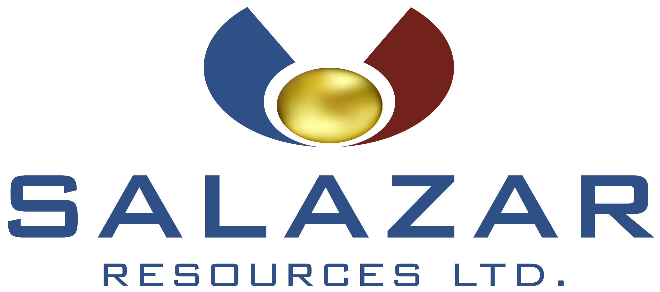
Regional drilling on the Agua Santa target (Figure 1) started mid-June 2021 and completed on October 3, 2021 with 11 drill holes having been successfully completed totaling 2,818 metres. VMS mineralization was identified in the first drill hole of the work program (CREG-008) designed to test the edge of a Mobile MT (“MMT”) airborne geophysical anomaly (Figure 1) that coincided with both favourable geology and surface geochemistry results from prospecting in nearby creek beds (see August 9, 2021 news release). Drill collar locations are summarized in Table 1 at the end of this news release.
CREG-011 was a step-out drill hole, collared from the same drilling platform as CREG-008 (see Figure 2) designed to undercut the massive sulphide mineralization on the same drill section. It intersected faulted, but fragmental looking massive sulphide mineralization from 40.35 to 43.70 metres grading, 0.76% copper, 1.39 g/t gold, 4.29% zinc, 12.5 g/t silver and 0.17% lead (Table 2). The intercept had a copper-rich top from 40.35 to 40.70 metres grading, 4.76% copper, 0.51 g/t gold, 0.91% zinc, 28.0 g/t silver, and 0.03% lead, and a zinc-rich base from 41.62 to 42.30 metres grading, 0.37% copper, 5.67 g/t gold, 19.92% zinc, 39.3 g/t silver and 0.77% lead (Table 2).
Table 2: Drill results for CREG-011
| Drill Hole (1) | From | To | Thickness | Cu (%) | Au (g/t) | Zn (%) | Ag (g/t) | Pb (%) |
|---|---|---|---|---|---|---|---|---|
CREG-011 | 40.35 | 43.70 | 3.35 | 0.76 | 1.39 | 4.29 | 12.5 | 0.17 |
including | 40.35 | 40.70 | 0.35 | 4.76 | 0.51 | 0.91 | 28.0 | 0.03 |
including | 41.62 | 42.30 | 0.68 | 0.37 | 5.67 | 19.92 | 39.3 | 0.77 |
- This is an early-stage exploration project, meaning geological modeling has not determined the orientation of stratigraphy to accurately determine an approximate true thickness for lithologies and mineralization
An interesting feature of CREG-011 is a wide, low-grade, sulphidized section of the host strata in the hanging wall of the faulted massive sulphide mineralization from 29.75 to 40.35 metres grading, 0.10% copper, 0.68 g/t gold, 0.26% zinc, 2.2 g/t silver, and 0.04% lead. This low-grade intercept suggests the hydrothermal system continued to exhaust mineralized fluids after the deposition of the massive sulphide mineralization. Further review is being undertaken to assess possible vectoring using data from adjacent drill holes.
CREG-009 was a step-out drill hole, collared 82 metres to the north-northeast of CREG-008 (see Figure 3) and although it intersected similar volcanic stratigraphy to CREG-008, it appears to have pierced the favourable VMS horizon hosting the massive sulphide mineralization (see August 9, 2021 news release), CREG-009 only intersected highly sulphidized, geochemically anomalous mafic volcaniclastic rocks. The best mineralization intersected in CREG-009 is related to a fault zone from 170.18 to 171.26 metres, grading 1.16% copper, 0.05 g/t gold, 0.01% zinc, and 1.14 g/t silver.
CREG-010 was a step-out drill hole, collared 47 metres to the southwest of CREG-008 (see Figure 4) and although it intersected similar volcanic stratigraphy to CREG-008 and CREG-009, like CREG-009, it appears to have pierced the favourable VMS horizon hosting the massive sulphide mineralization (see August 9, 2021 news release) but only intersected wide, highly sulphidized, geochemically anomalous section of mafic volcaniclastic rocks. Mineralization was intersected from 41.00 to 52.04 metres, grading 0.09% copper, 0.20 g/t gold, 0.25% zinc, and 1.7 g/t silver. A narrow section of higher-grade material occurs from 44.50 to 45.12 metres, grading 0.88% copper, 1.32 g/t gold, 2.26% zinc, 14.8 g/t silver and 0.01% lead.
The Partners continue to wait for analytical results to be completed and released from the laboratory for regional drill holes CREG-012 to CREG-018. It is understood that BV laboratory is experiencing a significant increase in through volume that is resulting in longer than expected delays for its clients to receive geochemical results. These delays are unfortunately hampering assessment and the interpretation of exploration programs including the relationship of any drill hole results to two prospecting showings of bedrock, fault-controlled VMS mineralization at Agua Santa. The laboratory delays are creating a major challenge for consistent exploration news flow. Once data from drilling and surficial geochemical sampling has been returned from the laboratory and passed the Partners’ internal QAQC protocols, the results will be disclosed.
Regional drill holes at El Panecillo, east of El Domo (CREG-003, CREG-005, and CREG-006), and at Selva Alegre (CREG-007) did not yield any significant results, although they intersected known strata in the volcanic edifice known to host the El Domo VMS deposit (Figure 1). Further assessment of the geochemistry is ongoing to determine if there are possible exploration vectors present that can be used for follow-up exploration work.
Pijili Project Update
During the second half of 2021, exploration activities continued to follow up on target generation results on the Mercy, Rosa de Oro, and Carmen de Pijili concessions that make up the Pijili project. Field activities included prospecting, geological mapping, hydrothermal alteration studies, and structural mapping that focused on the paragenetic sequencing of the veining and its link to possible epithermal and porphyry systems known to occur regionally.
On the Rosa de Oro and Carmen de Pijili concessions, the technical staff focused their work on the four high-priority targets called El Pato, Rosa de Oro, Naranjos and Papagayo discussed in the April 9, 2021 news release. Table 3 summaries total samples collected to date on Pijili project concessions supporting target generation and drill platform spotting. Copper and gold rock geochemistry is presented in Figures 5 and 6 respectively, and copper and gold soil geochemistry is presented in Figures 7 and 8, respectively. The technical team has concluded that El Pato is ready for final drill targeting, as it is the highest-ranking target on these two western concessions for Pijili project. The Partners have scouted drill platform locations for the El Pato target while planning and budgeting is being conducted for potential drilling in the first half of 2022.
Work at the Mercy concession finished in June 2021 with the completion of sampling over the newly discovered Ensillada porphyry system (see April 20, 2021 news release). Sampling included a detailed review of a newly established section of gravel road constructed through the Ensillada porphyry system by a local artisanal miner to access their property. All work since the completion of drilling and the discovery of the Ensillada porphyry system has confirmed the presence of a large hydrothermal system that remains open to the north, northeast and east. Copper and gold rock geochemistry is presented in Figures 9 and 10 respectively, and copper and gold soil geochemistry is presented in Figures 11 and 12, respectively. The technical team continues to review results to plan a follow-up exploration budget for 2022.
Table 3: Total sample summary for Pijili project
| Concession | Rock Samples | Soil Samples | Stream Sediment Samples | Drilling Samples | Lithogeochemistry and Petrographic Samples |
|---|---|---|---|---|---|
Mercy | 708 | 984 | 14 | 3,544 | 142 |
Maria (artisanal) | 74 | 13 | - | - | - |
Rosa de Oro | 360 | 563 | 13 | - | - |
Carmen de Pijili | 734 | 525 | 16 | - | - |
QAQC | 230 | 298 | - | 569 | - |
- All samples compiled in this table were collected between 2017 and present day by the Partner’s technical team
Santiago Project Update
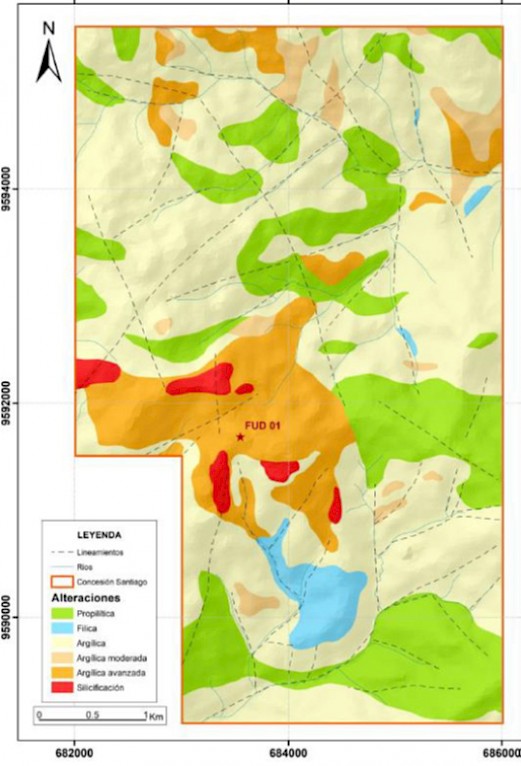
Technical crews have finished prospecting and geological mapping the entire Santiago concession, producing the first unified geological and hydrothermal alteration map (Figures 13 and 14). The target generation work has collected 1,053 rock samples bringing the total number of samples to 1,148 between 2017 and 2021. This is in addition to the 760 historical rock samples collected by Silex Ecuador S.A. (see June 2020 news release). Once data from the rock sampling has been returned from the laboratory and passed the Partners’ internal QAQC protocols, the results will be disclosed.
The principal target area at Santiago has coincident favourable geological and hydrothermal alteration suggesting a high-sulphidation porphyry system denoted by extensive quartz-alunite alteration, coincident historical geochemical anomalies for copper and gold over 2,200 metres by 600 metres, and a geophysical airborne MobileMT signature with both a low frequency apparent conductivity geophysical and resistivity anomaly of approximately 3,000 by 2,000 metres and TMI-RTP magnetic low of approximately 2,000 by 1,500 metres that is encircled by areas of higher magnetic response (see June 15, 2020 news release). The magnetic low is suggestive of magnetic mineral destruction from hydrothermal alteration.
This principal target is also coincident with historical drilling by Prospection and Newmont; however, a 3D review indicates that due to the short drill hole lengths of that era, these two historical drilling programs do not provide an explanation for the large MobileMT geophysical anomaly, which suggests that additional, deeper drilling is warranted. The Partners plan on twinning FUD-001 (Newmont drill hole) in Q1 2022, as part of a 2,500-metre drilling program. This program was delayed to accommodate additional community relations and social work with stakeholders that includes but is not limited to the Ecuadorian government and Indigenous leadership. Twinning Newmont’s FUD-001 drill hole is critical in not only validating their historical intersection of 323.09 metres, grading 0.23% copper and 0.40 g/t gold, but also examining the deeper MobileMT anomalies (see June 15, 2020 news release).
Technical Information and QAQC
The three Ecuadorean exploration projects (Curipamba, Pijili, and Santiago) are being managed and reviewed by Vice President Exploration, Jason Dunning, M.Sc., P.Geo., a Qualified Person within the meaning of NI 43-101. Salazar staff collect and process samples that are securely sealed and shipped to Bureau Veritas (“BV”) in Quito for sample preparation that includes crushing and milling to prepare pulps that are then split for shipment to their facility in Vancouver, Canada for analysis. All assay data have undergone internal validation of QAQC; noting there is an established sampling control program with blind insertion of assay blanks, certified industry standards and sample duplicates for the Curipamba project. A QAQC program is also in place at BV and includes insertion of blanks, standards, and duplicate reanalysis of selected samples. BV’s quality system complies with the requirements for the International Standards ISO 9001:2000 and ISO 17025: 1999. At BV, samples from regional drilling have silver and base metals analyzed by a modified ore grade 34-element aqua regia technique with ICP-ES finish. Gold is analyzed by fire assay fusion with AAS finish. Overlimit protocols are in place for gold, silver, copper, lead, and zinc.
Qualified Person
The technical information of this news release has been reviewed and verified as accurate by Mr. Jason Dunning, M.Sc., P.Geo., Vice President Exploration for Adventus, a non-Independent Qualified Person, as defined by NI 43-101.
About Adventus
Adventus Mining Corporation is an Ecuador focused copper-gold exploration and development company. Its strategic shareholders include Altius Minerals Corporation, Greenstone Resources LP, Wheaton Precious Metals Corp., and the Nobis Group of Ecuador. Adventus is advancing the Curipamba copper-gold project through a feasibility study, while continuing to explore the broader 215 square kilometre district. In addition, Adventus is engaged in a country-wide exploration alliance with its partners in Ecuador, which has incorporated the Pijili and Santiago copper-gold porphyry projects to date. Adventus also controls an exploration project portfolio in Ireland with South32 Limited as funding partner. Adventus is based in Toronto, Canada, and is listed on the TSX Venture Exchange under the symbol ADZN and trades on the OTCQX under the symbol ADVZF.
About Salazar
Salazar Resources Limited is focused on creating value and positive change through discovery, exploration, and development in Ecuador. The team has an unrivalled understanding of the geology in-country and has played an integral role in the discovery of many of the major projects in Ecuador, including the two newest operating gold and copper mines. Salazar Resources has a wholly owned pipeline of copper-gold exploration projects across Ecuador with a strategy to make another commercial discovery and farm-out non-core assets. The Company actively engages with Ecuadorian communities and together with the Salazar family it co-founded The Salazar Foundation, an independent non-profit organization dedicated to sustainable progress through economic development. The Company already has carried interests in three projects. At its maiden discovery, Curipamba, Salazar Resources has a 25% stake fully carried through to production. At two copper-gold porphyry projects, Pijili and Santiago, the Company has a 20% stake fully carried through to a construction decision.
Neither the TSX Venture Exchange nor its Regulation Services Provider (as that term is defined in the policies of the TSX Venture Exchange) accepts responsibility for the adequacy or accuracy of this news release.
This press release contains “forward -looking information” within the meaning of applicable Canadian securities laws. Any statements that express or involve discussions with respect to predictions, expectations, beliefs, plans, projections, objectives, assumptions or future events or performance (often, but not always, identified by words or phrases such as “believes”, “anticipates”, “expects”, “is expected”, “scheduled”, “estimates”, “pending”, “intends”, “plans”, “forecasts”, “targets”, or “hopes”, or variations of such words and phrases or statements that certain actions, events or results “may”, “could”, “would”, “will”, “should” “might”, “will be taken”, or “occur” and similar expressions) are not statements of historical fact and may be forward-looking statements.
Forward-looking information herein includes, but is not limited to, statements that address activities, events, or developments that Adventus and Salazar expect or anticipate will or may occur in the future. Although Adventus and Salazar have attempted to identify important factors that could cause actual actions, events, or results to differ materially from those described in forward-looking information, there may be other factors that cause actions, events or results not to be as anticipated, estimated, or intended. There can be no assurance that such information will prove to be accurate, and actual results and future events could differ materially from those anticipated in such information. Accordingly, readers should not place undue reliance on forward-looking information. Adventus and Salazar undertake to update any forward-looking information except in accordance with applicable securities laws.
For further information from Adventus, please contact Christian Kargl-Simard, President and Chief Executive Officer, at +1-416-230-3440 or christian@adventusmining.com. Please also visit the Adventus website at www.adventusmining.com and LinkedIn page at https://www.linkedin.com/company/adventus-mining-corporation.
For further information from Salazar, please contact ir@salazarresources.com.
Table 1: Drill Collar Information (UTM Datum – Provisional South American 1956, Zone 17)
| Hole ID | EAST | NORTH | ELEV | AZIMUTH | DIP | DEPTH | COMMENT |
|---|---|---|---|---|---|---|---|
CREG-008 | 691805 | 9851410 | 448 | 270 | -50 | 323.90 | Successfully completed per design |
CREG-009 | 691855 | 9851475 | 445 | 270 | -50 | 258.35 | Successfully completed per design |
CREG-010 | 691778 | 9851372 | 453 | 270 | -50 | 284.90 | Successfully completed per design |
CREG-011 | 691805 | 9851410 | 448 | 270 | -85 | 242.45 | Successfully completed per design |
CREG-012 | 691908 | 9851586 | 460 | 270 | -50 | 284.55 | Successfully completed per design; results pending |
CREG-013 | 691859 | 9851410 | 420 | 270 | -85 | 203.25 | Successfully completed per design; results pending |
CREG-014 | 691700 | 9851397 | 459 | 270 | -50 | 242.40 | Successfully completed per design; results pending |
CREG-015 | 691698 | 9851397 | 459 | 90 | -85 | 208.85 | Successfully completed per design; results pending |
CREG-016 | 691840 | 9851781 | 499 | 270 | -50 | 261.40 | Successfully completed per design; results pending |
CREG-017 | 691765 | 9852359 | 644 | 105 | -70 | 230.00 | Successfully completed per design; results pending |
CREG-018 | 691851 | 9851853 | 509 | 125 | -62 | 278.40 | Successfully completed per design; results pending |
Figure 1: Drill Plan Map for Curipamba Project
Figure 2: Drill Section CREG-011 (looking north) – Agua Santa Target, Curipamba Project
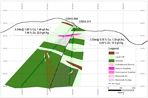
Figure 3: Drill Section CREG-009 (looking north) – Agua Santa Target, Curipamba Project
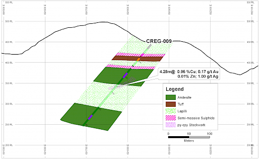
Figure 4: Drill Section CREG-010 (looking north) – Agua Santa Target, Curipamba Project
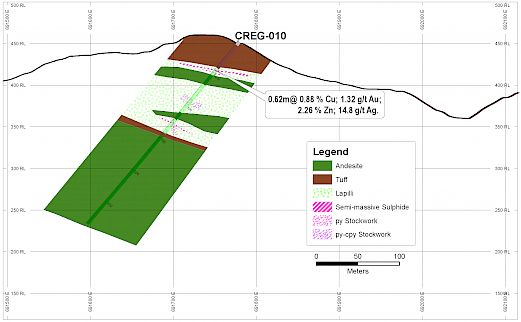
Figure 5: Rock Geochemistry Map (Copper) for Rosa de Oro and Carmen de Pijili Concessions, Pijili Project
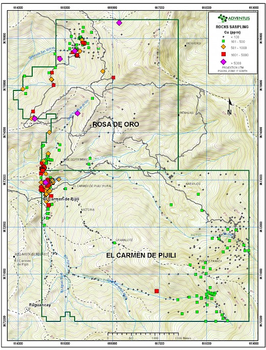
Figure 6: Rock Geochemistry Map (Gold) for Rosa de Oro and Carmen de Pijili Concessions, Pijili Project
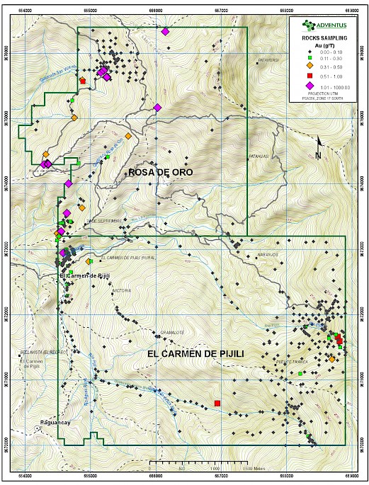
Figure 7: Soil Geochemistry Map (Copper) for Rosa de Oro and Carmen de Pijili Concessions, Pijili Project
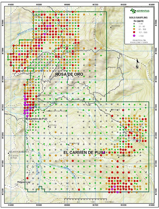
Figure 8: Soil Geochemistry Map (Gold) for Rosa de Oro and Carmen de Pijili Concessions, Pijili Project
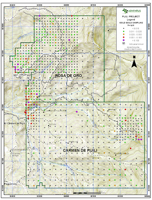
Figure 9: Rock Geochemistry Map (Copper) for Mercy Concession, Pijili Project
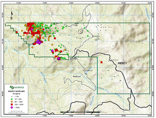
Figure 10: Rock Geochemistry Map (Gold) for Mercy Concession, Pijili Project
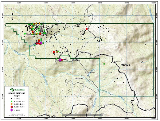
Figure 11: Soil Geochemistry Map (Copper) for Mercy Concession, Pijili Project
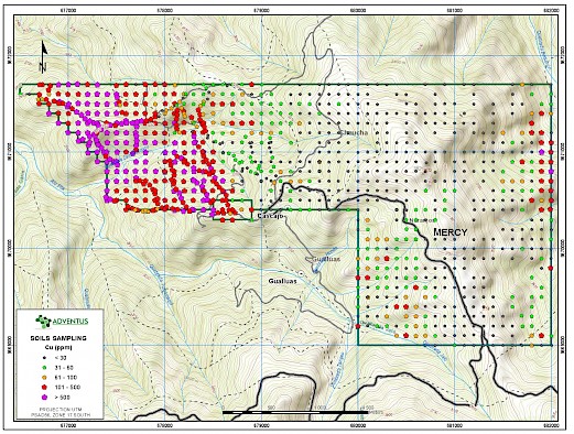
Figure 12: Soil Geochemistry Map (Gold) for Mercy Concession, Pijili Project
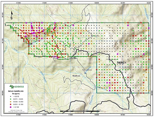
Figure 13: Geological Map for Santiago Concession
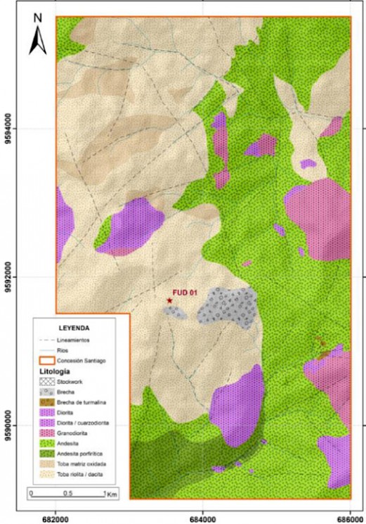
Figure 14: Hydrothermal Alteration Map for Santiago Concession